Top: A portion of ex-Representative Albert Hills’ abandoned 300 acres of farmland in Quikon after a report found he purchased it illegally. The DayLight/Esau J. Farr
By Esau J. Farr
ROCK CRUSHER – A former lawmaker of Bong County has abandoned a rubber farm after an investigation unearthed that he had illegally acquired the land on which it is planted.
Neither Albert Hills Jr., who served as representative of Bong County District #1 from 2018 to 2024, nor his workers have returned to the 300 acres for over three years, according to locals. This reporter observed the farm covered in bush.
“There is no new cutlass mark on that farm as we speak,” said David Kangar, the chairman of Quikon’s customary land leadership. “The guy he put over the farm has left the farm, and nobody comes there [anymore].”
Hill did not reply to questions and failed to answer calls placed to him.
The 2023 investigation had found that Hills paid an elder an undisclosed fee for the customary land in the Quikon Clan of Kokoyah District. The purchase violated the Land Rights Act, which prohibits such a deal until 2068.
The land in question is part of approximately 25,000 hectares for which Quikon is on the verge of getting a customary land deed. The Liberia Land Authority surveyed the land, confirming the clan’s landmass.
Asked what the community would do if Hills came back for the land, Kangar gave a firm response: “The community is going to take the land.”
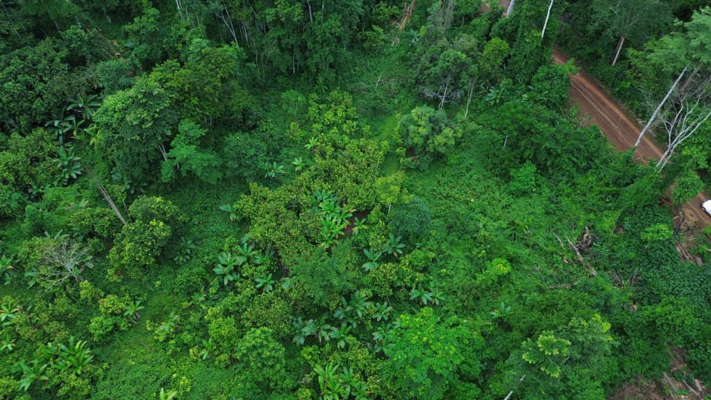
Top: Picture of thriving cocoa beneath tree skeletons located in B’hai Jozon, Grand Gedeh County. DayLight/Samuel T. Jabba
By Varney Kamara and Samuel T. Jabba
B’HAI JOZON, Grand Gedeh County – Local leaders in B’hai District, Grand Gedeh County, alleged they gave Superintendent Alex Grant about 4 million CFA (US$7.111) to get a deed for their ancestral land.
Last March, a delegation from B’hai met Grant at his Zwedru office and gave him the money, according to Jammie Kinyea, spokesperson of B’hai Jozon Management Council. Kinyea said they wanted the Superintendent to leverage his position to assist them in obtaining the deed.
“We were very happy when Grant took over. We thought his ascendency would help to complete the survey of our land to get our deed quickly,” Jammie Kinyea, spokesman of the B’hai Jozon Land Management Council, said in an interview with The DayLight in Toe Town, Grand Gedeh.
“Grant assured us that he would try his best for us to get our deed from the Liberia Land Authority. We tried without success. This is my disappointment,” Kinyea added.
Grant admits to receiving the money, but claims he received only about half of that amount. He said the money was paid through instalments—the first payment was made two months after the meeting, and the second six months later. Like in Kinyea’s case, The DayLight could not independently verify Grant’s claim, as he provided no evidence.
Grant said the money was intended to survey the land and resolve a conflict over it, and not for a deed. The dispute arose between two Burkinabees who were competing to plant cocoa on the land, Grant said.
“I personally suggested to them that to resolve this issue, we need to survey to know who owns what and who doesn’t. This was my way of trying to end the dispute,” Grant said. “That’s how they gave the money for the survey, and the surveyor went in there and did the survey.”
Grant went on to obtain a deed for the land. However, the deed was not in B’hai Jozon’s name as Kinyea and the townspeople had bargained for. Instead, the deed to the farmland was issued to the Grand Gedeh County local government. It was part of a 30-year lease agreement with Boubou Sebu, a Burkinabé businessman.
Barely a week after securing the deed, the Land Authority revoked it over irregularities.
Likewise, county authorities terminated their lease agreement following media reports that exposed violations and inconsistencies. A community acquires a customary deed through a legal process under the Land Rights Act. There is no evidence that B’hai has completed any of those steps.
Townsfolk in B’hai said they only learned that the lease agreement was intended for their land after it was cancelled.
Jimmy Kinyea and the townspeople of B’hai Jozon in Grand Gedeh County gave Superintendent Alex Grant money to help them get a customary deed. The DayLight/Samuel T. Jabba
Grant said the community undermined his efforts to acquire a deed apart from the one that was revoked. He said a draft of the document had been produced, but not been authorized by the Land Authority. Grant did not present a copy of the alleged draft deed, even though he promised to make it available to The DayLight.
Kinyea shrugged off Grant’s comments.
“If he says so, then that’s fine,” Kinyea said. “But all I want to say is that we are happy that the 500 acres that were taken away from us through the lease agreement have been returned.”
DayLight reporters observed thousands of hectares of abandoned cocoa farms on the disputed land. Most of the harvested cocoa is transported to Toe Town. In contrast, others are being shipped across the border town of Barcubley, La Côte d’Ivoire, according to Sonconpocodgou Yologo, spokesman of the Burkinabe workers in Pierre’s Village-1.
Top: The headquarters of the Liberia Land Authority on Ashmun Street, Monrovia. The DayLight/Harry Browne
By James Harding Giahyue
MONROVIA – On Monday, the Liberia Land Authority justified issuing a fraudulent land deed as part of an illegal cocoa cultivation agreement between Grand Gedeh authorities and a Burkinabe businessperson. It was responding to a DayLight investigation and another by the Liberian Investigator, accusing it of wrongdoings.
The DayLight had established that Chairman Samuel Kpakio violated a moratorium on public land transactions announced by President Joseph Nymah Boakai in this year’s State of the Nation Address. The investigation determined that Kpakio had masterminded the scam and was not misled, as the Land Authority had claimed.
The Liberian Investigator, on the other hand, found evidence that the deed was illegally issued to two entities: the Grand Gedeh Local Government Reserved Farmland and Moore Agro Inc., co-owned by ex-Minister of Public Works Gyude Moore.
The Land Authority revoked the deed in question, while Grand Gedeh County authorities terminated their agreement with the Burkinabe farmer.
In a press release, the Land Authority defended Kpakio’s actions about two weeks after The DayLight investigation. It said accusations against Kpakio were “unsubstantiated,” meant to tarnish his reputation, and “derail” donors’ attention.
“The Liberia Land Authority wishes to inform its implementing partners that the moratorium issued has halted all leases and sales of public land. Thus, the development grant deed signed was in no way a violation of the moratorium,” the release read.
It restated the suspension of Paye Freeman, the Grand Gedeh Land Administrator, and David Togbasie, county land dispute officer. The Land Authority blames the two men and Grand Gedeh Superintendent Alex Grant for “misleading” Kpakio into issuing the deed. All three men declined to speak on the matter.
But an analysis of the Land Authority’s justification, a relook at the deed, laws and regulations, and interviews with people knowledgeable of the land sector, corroborated the newspapers’ publications. The evidence further exposed the institution’s attempt to scapegoat and lessen Kpakio’s role in the illegal activities.
The moratorium, which was lifted in August, did not mention the phrase “development grant deed.” However, the facts contradict the Land Authority’s defense. A development grant deed can be issued only for public or government land, under the Land Rights Act.
The 2018 law categorizes land into private and customary, government and public, whose sale and lease the Land Authority oversees.
The Liberia Land Authority issued a fraudulent deed to Grand Gedeh County authorities as part of a scam to lease out 500 acres of land to a Burkinabe businessman. The DayLight/Carlucci Cooper
“Development grant deeds come from public land because the Land Authority manages public land,” said a person familiar with the entity’s workings. “Development grant deeds cannot be issued on private land, government land (normally already allocated), customary land, unless in certain cases.”
Even other government institutions could not get a deed during the time of the moratorium, according to the source. They got an attestation, one of which The DayLight has seen.
The source said the Liberia Land Authority’s board of commissioners was instituting a “stricter process” for development grant deeds to avoid such abuse. “Though not chronological, there are ongoing discussions to streamline the development deed process,” added the source.”
Two lawyers and an ex-executive of the Land Authority, who also preferred anonymity, agree with the source.
“A development grant deed is taken from the public land domain. Therefore, if a moratorium is placed on public land, that also includes a moratorium on the granting of Development Grant Deed to whoever,” the ex-executive told The DayLight.
Kpakio’s issuance of the deed to Grand Gedeh and Moore Agro Inc. undermined the very reason why the moratorium was imposed. It was meant to curb land grab, prevent conflicts and promote sustainable land-based investment. The President had said it would remain in place until the agency created regulations and guidelines to govern these things.
Moore, the ex-Public Works Minister, who owns 70 percent of Moore Agro Inc.’s shares, denies knowledge of the deed. He told The DayLight, “I have no idea what this is about. Moore Agro Inc. has nothing to do with Grand Gedeh or land.”
A person familiar with the deed processing said Moore Agro Inc. might have mistakenly copied from an old deed. The experts said the likely mistake could be the result of hasty work, a common feature of fraud or forgery.
By issuing the deed, the Land Authority violated several provisions of the Land Rights Act and Regulations. It failed to investigate whether the 500 acres of land in Grand Gedeh’s B’hai District were public or customary land. It did not consult landowning towns and villages, or get their consent, the most crucial aspect of land reform. The survey was kept secret, and there was no competitive bidding.
But those were not the only violations, though.
Kpakio signed the deed two days before the survey of the land was completed, against standard procedure. David Sluwar, who conducted the survey, was not licensed for a government or public land survey. Rather, Sluwar is licensed to survey only private plots, based on the official surveyors’ register. The Surveyors Licensing and Registration Board did not respond to a DayLight inquiry on Mr. Sluwar’s role in the scandal.
Integrity Watch Liberia provided funding for this story. The DayLight maintained complete editorial independence over the story’s content.
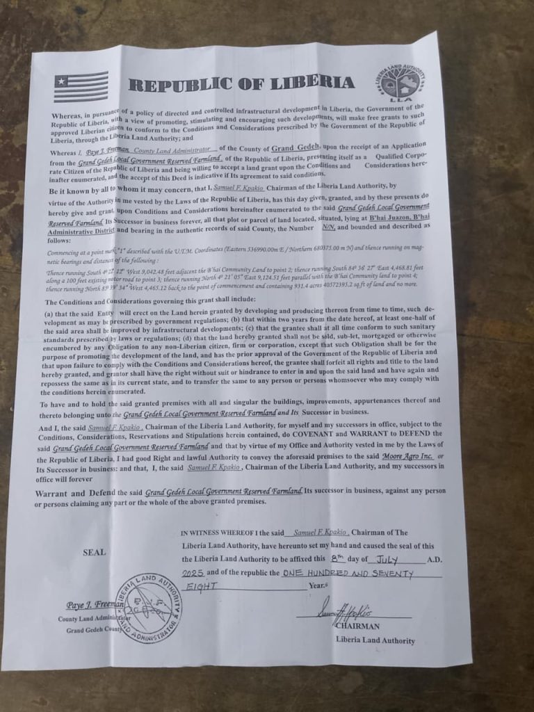
Top: The Chairman of the Land Authority, Samuel Kpakio, illegally signed a deed as part of a fraudulent cocoa agreement between Grand Gedeh County and a Burkinabé businessman. Filed picture/Liberia Land Authority
By James Harding Giahyue and Varney Kamara
The Chairman of the Liberia Land Authority, Samuel Kpakio, signed a deed for a 500-acre cocoa farmland in Grand Gedeh County, violating a moratorium that President Joseph Boakai pronounced in the State of the Nation Address.
The transaction was a part of a fraudulent agreement between Grand Gedeh County and a Burkinabé cocoa farmer, which, authorities say, has been terminated
The surveyor who surveyed the land is unauthorized to conduct a government survey. Mr. Kpakio even signed the deed before the surveyor completed his work.
The survey was secretly conducted, and there was no record that the land was put out for competitive bidding as required by law
The deed was issued to an unlawful, inexistent recipient
MONROVIA – Over the weekend, the Liberia Land Authority said Grand Gedeh County Superintendent Alex Grant “misled” it in a fraudulent cocoa farming agreement with a Burkinabé businessman. The 30-year deal, worth US$600,000, has been canceled, according to county officials.
“The Superintendent and the County Land Administrator of Grand Gedeh misled the … [Land Authority] during the issuance and signing of the said deed, thereby bypassing established procedures and guidelines required for granting a development grant deed,” the Land Authority said in a statement. It provided no evidence to back that claim.
The Land Authority revoked the deed and suspended two staffers in its Grand Gedeh Office in connection with a deal that targeted 500 acres of ancestral land in the B’hai District. It said it was investigating Paye Freeman, the County Land Administrator, and David Togbasie, Land Dispute Officer. The two men would not speak on the matter.
But a DayLight investigation has uncovered that the Chairman of the Land Authority, Samuel Kpakio, masterminded the deal. Government documents and interviews with officials revealed that Kpakio violated a moratorium to support the agreement. The Land Authority boss utilized an unauthorized surveyor and skipped the legal processes, as mentioned in the weekend press release. The deed was even intended for an unlawful recipient.
The DayLight obtained the deed in question for the 500 acres and observed several issues with the document.
First, Kpakio signed the deed on July 8, 2025, when the moratorium on public land sale was active. The moratorium was issued last year and announced by President Joseph Boakai during this year’s State of the Nation Address, pending the creation of guidelines to prevent land-grabbing.
“These efforts aim to enhance tenure security, resolve conflicts, and promote sustainable land investment throughout Liberia,” the President said. It was lifted on July 31, 2025, twenty-three days after Kpakio signed the deed.
In Friday’s press release, the Land Authority detailed the accusations against Mr. Grant, citing provisions in the Land Rights Act he had allegedly violated. However, the institution glossed over its own actions and inactions, failing to say why it suspended the staffers. This concealed Kpakio’s role in the scandal, while shifting blame to Grant, Freeman, and Togbasie.
While Freeman and Togbasie’s roles in the scam are unclear, the evidence establishes Mr. Grant’s wrongdoing: not obtaining the community people’s consent. However, Mr. Kpakio’s blame game contradicts his position as head of the Land Authority.
Mr. Kpakio is no stranger to land matters. Before being appointed Chairman of the Land Authority, Mr. Kpakio served as director of land use planning and management with “distinction,” according to the institution’s website. Moreover, the Liberia Land Authority was established as a “one-stop shop” for land transactions countrywide, not the Office of the Superintendent.
The DayLight caught up with Mr. Grant in Paynesville on Saturday, but he declined an interview. However, he had admitted to his wrongdoing before canceling the agreement.
“I regret that the locals were not informed by the district’s authorities. I think is a procedural error,” Grant told a team of reporters in an interview in Zwedru City. “Once they don’t agree, and we agreed, we can both come to the negotiation table and have a conversation around it.”
A copy of a fraudulent deed bearing the signature of the Land Authority’s Chairman, Samuel Kpakio
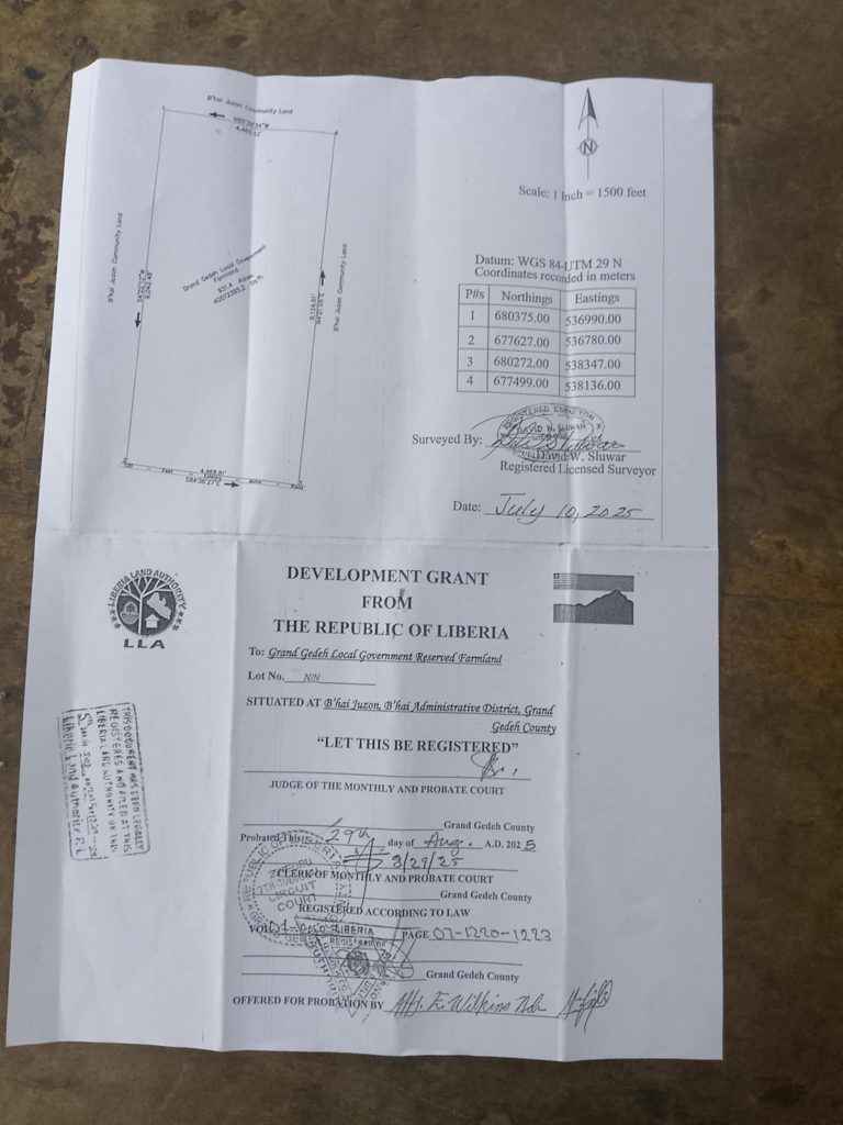
Second, The DayLight also observed another irregularity with the deed Kpakio signed that has nothing to do with Grant. David Sluwar, a licensed private surveyor, had surveyed the land and signed the document, a red flag, the surveyor’s roster shows. A private land surveyor does not survey a government plot; there are 56 government surveyors registered to do this job.
People familiar with public land procedures and processes believe Sluwar played a crucial part in the scandal. “No government surveyor could have signed that deal,” said one official, who asked not to be named over fear of retribution.
There is another issue regarding Mr. Sluwar, though. Mr. Kpakio signed the deed before the private land surveyor completed the survey, another red flag. The document shows that Mr. Sluwar signed it on July 10, two days after Mr. Kpakio. In normal land transactions, the Chairman of the Land Authority signs a deed after the survey is completed, not before.
Furthermore, details of the survey were not published in line with the Land Rights Regulation. The 2022 instrument calls for published details of a government land survey to be published in a government gazette, in at least two newspapers and radio stations, in local languages.
The regulation also requires the Land Authority to publish a survey notice for at least one month. Like the details, there is no record that a survey notice was published.
The Chairman of the Land Authority, Samuel Kpakio, signed the deed before the survey was completed.
Efforts to get Sluwar’s side of the story did not materialize. His mobile phone number was switched off on Sunday and Monday, and he did not respond to text messages. The DayLight has contacted the Surveyor Licensing and Registration Board about Mr. Sluwar’s role in the scandal.
Third, The DayLight gathered evidence that the Land Authority did not vet the land in question before Kpakio signed the deed. Normally, its vetting department verifies whether there are issues.
Failure to verify explains why the agency did not identify that the 500 acres were customary land. The land, located on the Liberia-Ivory Coast border, was unused because it is a far-to-reach area. However, the plot is easily accessible from the Ivorian side.
Fourth, there is no record that the land in question was put out for a competitive bidding process as mandated by the Land Rights Act.
The newspaper observed one more inconsistency. The deed was granted to the Grand Gedeh Local Government Reserved Farmland, which does not exist. A development grant deed is not awarded to a farmland. Rather, it is issued to a person, an institution, an NGO, or any legal entity. In fact, such a deed is so delicate that the new guidelines require the signatures of three commissioners.
Mr. Kpakio evaded all The DayLight’s efforts for an interview. He did not respond to detailed questions on WhatsApp on Sunday and directly to his office on Monday. He also declined an interview on Tuesday and was unavailable on Wednesday.
Regardless, Mr. Kpakio’s well-documented actions contradict his induction speech in February, in which he spoke about reforming the Land Authority.
“There will be no room for unethical and unprofessional conduct, both in administration and in our interactions with our development partners and the Liberian public,” said Kpakio.
“The Liberia Land Authority will operate differently this time. Our work will be grounded in our core values: quality service delivery, transparency, fairness, accountability, integrity, professionalism, and respect.”
[Additional reporting by Paul Rancy in Zwedru, Grand Gedeh County]
Integrity Watch Liberia provided funding for this story. The DayLight maintained complete editorial independence of its content.
Top: A screengrab of a drone video showing a portion of a cocoa farm in Bargblor, Cavala District in Grand Gedeh County. The DayLight/Carlucci Cooper
By Carlucci Cooper
ZWEDRU – The Liberia Land Authority has charged two communities in Grand Gedeh County US$11,900 to cut their boundary, dragging a dispute over Burkinabe cocoa farmers.
Early last year, Bargblor and Tojallah in the Gbao and Cavalla Districts started a boundary dispute involving Burkinabé cocoa farmers. After a police probe and a court intervention, the matter was passed to the Land Authority for a settlement, which imposed the fee.
The majority of the money covers transportation, allowance and data collection, and administrative costs, according to an estimated budget obtained by The DayLight.
Townspeople in Bargblor said they paid US$500 against the charge, but presented no evidence. Those in Tojallah, on the other hand, said they had paid US$170 for “registration, transportation and mediation” to Daniel Togbasie, County Land Dispute Officer.
“They told us we had to pay a hundred US dollars each just for them to listen to us,” said Peter Carr, a Tojallah elder. “That’s just to hear the case, not even to get the survey done. And now, they want us to cough out nearly US$12,000 before they can even step on our land.”
The charge is inconsistent with the Land Rights Act, which puts the responsibility for boundary harmonization on the government. The law was passed in 2018, granting customary communities ownership of their ancestral territories, ending decades of marginalization. However, neither Tojallah nor Bargblor has established their boundaries, a crucial part of the law.
Campaigners, who have seen the document, said the Land Authority was pricing the communities out of their rights.
“Yes, it’s true the Land Authority charges fees to carry out customary land activities under the fees and regime, but it’s wrong to charge customary communities this much,” said Alphonso Henries, the coordinator for NGOs working on land reform in Liberia.
“The law is intended to build the economic strength of the people and not to deprive them. The Land Authority’s action was wrong and hasty. I think they went too far to exploit the situation,” added Henries.
The Liberia Land Authority has charged Tojallah and Bargblor US$11,900 to resolve their dispute.
Togbasi and Paye Freeman, Grand Gedeh’s Acting Land Administrator, who approved the charge, said they were not authorized to speak on the matter. Kweshie Tetteh, the Land Authority’s communication director, who has that authorization, justified the charge in a Monrovia interview.
“Tojallah and Bargblor are not just a case of customary land formalization,” said Tetteh. “This is a dispute referred from the court. In these instances, we don’t follow the customary process, so the payment responsibility falls on both parties.”
Tetteh added that Tojallah and Bargblor were not project communities and that the Land Authority did not have funding for formalization activities. “The fees could even be higher than this, depending on the size of land and workload,” Tetteh said. He added that the Land Authority, which has US$1,715,260 in the current National Budget, had no money for customary land processes, except for donations.
But the facts contradict Tetteh’s comments. The Land Rights Act Regulation does not mention fees for any activities, except for a “reasonable” amount that communities determine. In the last five years or so, the Land Authority has been drafting a fees regime, but has yet to complete the process. Even so, the breakdown of the US$11,900 is inconsistent with the draft fees regime seen by The DayLight.
The budget the Land Authority’s Grand Gedeh Office presented includes: US$6,300 for allowance for employees, US$2,000 for survey, US$1,200 for Monrovia-based personnel transportation and US$1,600 for administrative costs. This is a far cry from the US$50 and US$100 for most transactions in the draft fees regime.
“To ask communities to pay any money outside of the law can be interpreted as an attempt to deprive communities of their deeds,” said Daniel Wehyee, the lead land rights campaigner at the Sustainable Development Institute (SDI).
“If the Land Authority says communities need to pay money before intervening in boundary disputes, then it means the Land Authority is undoing, is undermining the implementation of the Land Rights Act.”
Furthermore, Tetteh’s suggestion that the court case erases the communities’ customary profile is misleading. Alternative dispute resolution (ADR) also applies to customary communities, meant to prevent or resolve land conflicts. It was the fear of these conflicts causing Liberia’s next civil conflict that led to the establishment of the Land Authority.
Stalled
The Tojallah-Bargblor dispute started when men of Tojallah abducted a group of Burkinabe farmers working for Bargblor on a farmland in a place called Karblee. Local people are hosting Burkinabes to plant cocoa in a cross-border joint venture. As of last month, the Liberia Immigration Service registered over 36,000 Burkinabes in Grand Gedeh alone.
Tojallah claims Burkinabés working for Bargblor crossed the Thwanee Creek, their boundary with Bargblor. On the other hand, Bargblor insists that the creek falls within their traditional territory and that the true boundary was Dulee, further into Tojallah.
After several failed mediation attempts, Bargblor filed a complaint with the police, which jailed a host of Tojallah townsmen. Later, the matter was forwarded to the Zwedru Magisterial Court, which then transferred the matter to the Land Authority for settlement.
An elevated view of the Thwanee Creek, which Tojallah argues is the boundary with Bargblor. Their neighbors, however, disagree, sparking a yearlong dispute. The DayLight/Carlucci Cooper
“Most of the cases we receive are customary land cases, so we forward them to the Land Authority with an arbitration team, who will establish who the rightful owner of the land is. And we’ve been able to achieve this with the help of the community leaders,” said T. Shad Dweh, Senior Associate Magistrate.
The Land Authority’s excessive request has dragged the dispute, with tensions flaring in the area. People from both sides of the conflict accuse the other of spoiling their crops and people fear walking alone in an area known for intermarriages.
Paul Rancy in Zwedru, Grand Gedeh County, contributed to this report.
Top: A townsman speaks with the Land Authority and Parley Liberia fieldworker in Gbarmue, a town in the Jorpolu Clan, Jorquelleh District in Bong County. The DayLight/Varney Kamara
By Varney Kamara and Harry Browne
GBARMUE – Townspeople in a Bong clan have registered their homes to own the land on which their houses sit. It is the first since Liberia passed the Land Rights Act nearly seven years ago.
The law requires communities to set aside residential areas in parts of customary land for homes and protect residents’ rights; however, this provision has not been enforced since it was established in 2018.
“The fact that this project is going on in the community, people have already started coming together to settle land disputes, leading to reconciliation among our people,” says Moses Kotogboe, Jorpolu’s Clan Chief, whose house was registered earlier during the exercise.
“This will allow us to preserve our culture and inheritance from our ancestors. This is important and unique for us. It’s a blessing for our community.”
In Gbarmue, 17 kilometers from Gbarnga, the capital of Bong County, enumerators visit houses, recording GPS coordinates and collecting household details, including the owner’s name, number of rooms, and exact location.
Parley Liberia, a Gbarnga-based NGO, is leading this first residential registration, also taking place in Grand Bassa, River Cess, and Bong Counties.
Nearly 300 homes have been registered under the trial, and the process is expected to be replicated in other parts of the country. Fieldworkers are recording all structures in the town, using geolocation.
Roseline Mulbah, Parley Liberia’s senior project officer, marks a house in Gbarmue, Jorpolu Clan, as part of a residential plot registration. The DayLight/Harry Browne
Gbarmue, for “tall palm tree” in the Kpelleh language, is the headquarters of the Jorpolu Clan, Jorquelleh District. It has applied and demarcated its borders with neighboring clans. It has only the Liberia Land Authority to conduct an official survey to acquire a customary land deed.
Though a moratorium on public land transactions, imposed in February, has stalled Jorpolu’s quest for a deed, the restriction does not affect the residential home registration. People will get a certificate at the end of the exercise, legalizing their ownership.
Gbarmue’s townspeople welcome the development, including women. Despite their legal rights to ancestral plots, their male relatives and traditional beliefs continue to deny them.
“Hearing about people like us receiving certificates for our homes and the land we are sitting on, I am too happy,” says Nancy Weedor, a Gbarmue resident and owner of a four-bedroom house. “This will enable us to plant our cassava to earn something … and allow us to support our homes.”
In the coming weeks, a full list of homeowners will be published for verification and thereafter, residents will apply for residential certificates, according to organizers.
“Residents will apply to the LLA for residential certificates, which will be signed by the [community land leaders] and the town chief before issuance,” says Roseline Mulbah, Parley Liberia’s senior project officer.
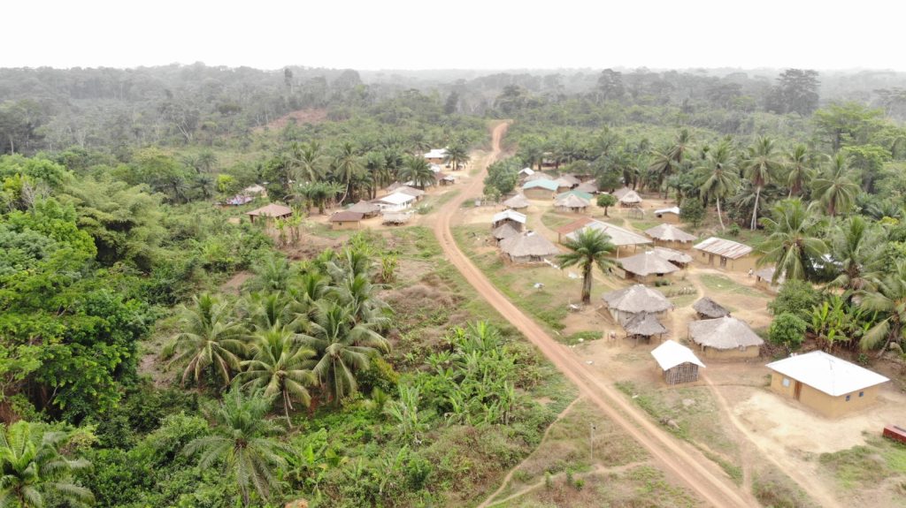
Top: Rock Crusher Town in Quikon, Kokoyah Statutory District in Bong County. The DayLight/Derick Snyder
By Esau J. Farr
ROCK CRUSHER – A clan in Kokoyah District, Bong County, is close to qualifying for an official survey for a customary land deed. The Quikon Clan recently signed boundary MoUs with its neighbors, the Vehn and Sawulah Clans, leaving it close to completing the legal process.
“The signing of the MoU will help stop conflicts among the present and future generations because the document will show them the boundaries of our land,” says Hellen Kpelletay, a Quikon resident. “It is important for us because it will help end confusion among us and other clans near us.”
In August 2023, Quikon self-identified as a landowning community, the first step in getting title to an ancestral territory. It later adopted a bylaw and constitution, established a community land governance structure, and conducted mapping in line with the Land Rights Act.
The law recognizes collective ownership for people who have lived in areas for generations, once they meet legal requirements. Before the law, rural dwellers were considered caretakers of customary land, not owners.
Quikon is one of the 39 communities Parley Liberia, a Gbarnga-based NGO, is assisting as part of a 3.5 million project provided by the Sweden-based International Land and Forest Tenure Facility.
Before the MoUs, Quikon had disagreements with Vehn and Sawulah on the north and the Sawulah Clan southwest.
For the issue with Vehn, Togar Glaygbo, a Quikon elder, claimed a plot of land there with some cash crops. However, his claim was rejected by some townspeople, including Vehn’s Clan Chief Amos Gardea. Gardea argued that Glaygbo had deserted the area for decades. The disagreement was later resolved after the interventions of local leaders and Parley Liberia.
“We agreed to resolve the matter for the sake of peace. We are one people, from the same background,” says Amos Gardea, the Clan Chief of Vehn.
“I am happy because after the signing of the boundary MoU, I heard that my village, I have in Vehn Clan, is still there for me,” Glaygbo tells The DayLight.
Unlike Vehn, Quikon’s dispute with Sawulah lasted for several years. It was a boundary dispute between Doe Town in Quikon and Nangboe Town in Sawulah. Doe Town argued that a creek was the boundary, while Sawulah contended it was further into Quikon. Later, Sawulah accepted Quikon’s argument.
Very happy
The ceremony for the boundary MoUs was witnessed by Bong County Land Administrator, Amelia D. Cassell, who appreciated locals for their efforts.
“Once the MoUs were signed successfully today, we have hopes for the next step (confirmatory survey),” says Cassell. “The MoU signing is a very good thing because it is in the interest of the citizens, and the various clans around us will benefit.”
David Kangar, Quikon Land Development and Management Committee, called on the Land Authority to complete he process.
“I am very, very happy because I see a way forward. I see the people of Quikon receiving their deed soon,” says Roseline Mulbah, Parley Liberia’s program officer. “It was very, very difficult for us to reach this far.”
To complete the Quikon boundary process, locals must survey a portion of land where the Jor River in Bong meets the St. John River. Once that boundary is established, the LLA will conduct an official survey and present the clan with a customary land deed.
Top: Clan Chief Mary Garpu of Dorbor receives the clan’s customary land deed. The DayLight/Harry Browne
By Harry Browne and Aaron Geezay
YARPAH TOWN – Several clans in River Cess recently received customary deeds, granting them the right to manage and benefit from lands left behind by their ancestors.
On December 10, 2024, the Liberia Land Authority(LLA) presented customary deeds to Gbarsaw, Dorbor, Ziadue, and Teekpeh Clans in River Cess County, formalizing the communities’ ownership.
Then 10 days later, the Siahn Clan in Central River Cess District and the Togba-Nyankun Clan in Fen River District received theirs.
“Today has become one of the happiest days of my life,” said Samuel Vonziah, chairman of the Gbarsaw Community Land Development Management Committee, fighting back tears.
“When you see me coming down with tears, it is tears of joy, tears of pain, the kind of struggle that we have been through, and other people who struggled with us in the past. All this represents the difficulties we underwent. As communities celebrate this historical moment, we hope for a new beginning that would improve their lives,” Vonziah added.
Edith Gbukpa, a women’s leader of Siahn, celebrated the milestone similarly. “In the past, our parents used to be caretakers of the land, but we are so happy today that we have right over our land.”
The latest issuance increases the number of communities with customary deeds to at least 27 from a list of 21 as of September last year, according to official records. Five more communities are poised to be issued customary deeds, while 30 have registered and conducted confirmatory surveys, representing over 1.3 million acres of land.
The six clans’ progress followed the completion of several processes that qualified the communities, including community self-identification, participatory mapping confirmatory survey, and. Before granting the property deeds, land authorities ensured all land disputes within the clans were amicably resolved.
An elevated view of a portion of Teekpeh Clan’s 65,224.61 hectares of land. The DayLight/Derick Snyder
Obtaining the deed is a break away from the old days.
In the past, communities struggled to get their deed. The right of customary people to own land in Liberia was only recognized in 2018, 171 years after independence. Historically, customary land rights were often overlooked and disregarded.
The Aborigines Law enacted in 1956 weakened the rights of Indigenous people by disregarding customary land rights, experts say. The move denied native people legal ownership of land without written deeds, emphasizing control and ownership by the state.
In response to the growing threat posed by land disputes, Liberia, backed by the international community, enacted the Land Rights Acts, which recognizes and protects customary land ownership.
Hailed home and abroad as a landmark achievement, the law recognizes customary land ownership, following decades of deprivation.
“Our land is for us now,” said Nancy Garpu, Clan Chief of Dorbor Clan. “It wasn’t for us at first. It was for the government but now the land is ours. So, I am happy that we have gotten our deed. When I go to my home, it is dancing that we will carry on there.”
The deeds now give communities the freedom to decide how to manage and benefit from the resources of the land, providing them with a window of opportunities to attract investment for local development.
Six of River Cess’ 34 clans now have a customary land deed. The DayLight/Harry Browne
“This is the time to lobby for companies. The reason why we struggled for the deed,” said Onesimus Charles, chairman of the Teekpeh Community Land Development and Management Committee. “I am confident that this deed would ensure the protection and promotion of our customary land.”
“We are grateful that we were able to educate our people on the processes leading to the acquisition of their deeds and awareness about their rights. This is a result of that engagement you see here today,” said Winston Siaker, a representative of the SDI. “It means we are graduating from the past, where people will no longer say women cannot own land but only boys children.”
Borbor Boeyon, River Cess County Land Administrator. Boeyon disclosed five other River Cess clans are in the process of obtaining their deeds. Boeyon added that many of River Cess’ 34 clans had started the deeding process but were at the boundary demarcation level.
“The land will now be under the clans’ protection and they are going to do what they can do,” Boeyon told The DayLight on the margins of the deeding ceremony in Yarpah Town. “Unlike before, the government will not just move in an area and say, ‘We are taking this portion of land from you.
Top: Some members of the network’s leaders at the Second National Land Conference last month in Ganta, Nimba County. The DayLight/ Harry Browne
By Esau J. Farr
GANTA, Nimba County – Communities in rural Liberia seek a customary deed to their ancestral lands but are plagued by boundary disputes.
Now, a new group, the Southeast Regional Network of Community Land Development and Management Committees, has been established to help resolve border conflicts and enable communities to acquire deeds much faster.
“We will identify the concerns and claims of communities, [and] involve the elders and traditional people for a peaceful resolution…,” says Augustine Dweh, chairperson of the network. Dweh spoke to The DayLight at the sidelines of the Second National Land Conference in Ganta last month.
“We understand that land disputes scare away development and that’s why we want to be serious about resolving disputes in our communities for us to live in peace,” adds Dweh.
Dweh’s community, Chedepo District, River Gee, does not have any dispute with its neighbors. However, several southeastern communities do. For instance, Lower Bokon, a clan in Sinoe’s Jaedae District, has had its quest for a deed stalled due to an issue with Neekleakpo, a town on the Grand Kru border.
Established this year, the network has more than 70 communities seeking a customary deed, according to the Sustainable Development Institute (SDI), the Margibi-based NGO that helped form it.
The Land Rights Act of 2018 gives communities ownership of customary land, but their ownership must be formalized by meeting certain requirements.
The process begins with locals self-identifying as a landowning community. They are required to create a bylaw and constitution, organize a governance body and cut boundaries with their neighbors. Then the Liberia Land Authority should conduct an official survey and present that community a customary deed.
The network also seeks to build its members’ capacity and increase awareness of land rights and issues.
Communities in Liberia heavily depend on over a dozen NGOs and development institutions to guide them through legal requirements for customary land deeds.
To date, 30 communities have been issued deeds, according to the Land Authority. In addition, 21 statutory deeds have been issued, 50 communities have completed the survey process, and five are waiting for their deeds.
There is a growing call for the Land Authority to fast-track the process, while NGOs criticize the regulator for prioritizing certain communities. The Land Authority blames the delay on poor funding and the lack of coordination with NGOs.
SDI helped form the network with funding from the US-based Rights and Resources Institute (RRI). The network intends to use peaceful traditional means to resolve existing and future boundary conflicts without the direct involvement of NGOs.
Members of the SRNCLDMC and SDI’s staff. Photo credit: Sustainable Development Institute (SDI)
“Due to the absence of a regional and national body of the land sector, issues and challenges from the communities are difficult to handle or address,” says Daniel Wehyee, the coordinator of SDI’s community land protection program.
“The coming together of the communities will provide [them] opportunities to mobilize resources and strengthen its operations,” adds Wehyee. He says the establishment of the network presents an opportunity for community land rights actors to come together and champion their cause.
Last month, members of the network elected Dweh as chair, Mamie Freeman of Sinoe co-chair, and Jacob Nyamah of Maryland secretary general. Relevance Zeon of Grand Gedeh took the financial secretary position, while Tetoe Davis of River Cess and Anabel Sewon of Grand Kru clinched treasurer and chaplain, respectively.
The network seeks funding from national and international partners for the empowerment of its members at all levels. Lack of logistical support and funding to empower CLDMCs across the country delays customary land formalization processes.
“If we have bikes to visit our regional communities,” Dweh says, “it will help us settle boundary disputes to fast-track customary land formalization process.”
Top: A GVL truck transporting palm bunches in January 2023. The DayLight/James Harding Giahyue
By Matenneh Keita
DU-WOLEE, Sinoe County – Golden Veroleum Liberia (GVL) is progressing with a new MoU with affected communities in Sinoe’s Kpanyan District. However, that progress comes six years after the deadline given by the global oil palm industry’s regulator.
In 2018, the Roundtable on Sustainable Palm Oil (RSPO) ordered GVL to turn its current MoU with the Du-Wolee Nyennue Township into a permanent one within a month. The RSPO threatened to terminate GVL’s membership with the regulator, which could hurt the company’s brand.
But over six years after that order, GVL has not signed the new MoU, though it has recently relatively complied. The company presented locals with a daft MoU for the township’s input, according to several people The DayLight interviewed.
“We went to work, we finished with everything. Now we are coming to carry [the MoU] to them,” said Stephen Browne, Du-Wolee land rights committee’s chairman.
Progress followed pressure from the community. Augustine Jerbo, a member of Du-Wolee’s MoU committee, said townspeople had given GVL a year to draft the MoU. In March last year, the company presented the draft.
Liberia’s largest oil palm company, GVL signed a 65-year agreement with the country in 2010, covering 220,000 hectares of land in Sinoe, Maryland, Grand Kru, River Gee and River Cess. The deal costs US$1.6 billion.
After the agreement, GVL signed an MoU with Du-Wolee Nyennue, guaranteeing the company over 2,367 hectares in the township. However, it obligates GVL to build clinics, schools and roads, and provide water for communities affected by its operations.
In 2013, Du-Wolee Nyennue joined other communities to file a complaint against GVL with the RSPO. The township accused GVL of encroaching on their land and coercing them to sign an MoU.
In 2018, the RSPO confirmed the accusations and ordered GVL to redo the MoU. The watchdog commanded GVL to work with the Liberian government to settle boundary disputes related to lands it sought to develop.
GVL is complying with the order, based on documents and interviews with representatives of the townspeople.
The National Bureau of Concessions (NBC) is working with the communities to develop the MoU. “We are right now at the point of finalizing the type of MoU,” then-Director General Edwin Dennis told The DayLight in July.
“Either we consolidate all those MoUs into one MoU, addressing all of the issues or keeping [the MoU] community-specific,” Dennis added. He said NBC’s legal department worked with the communities but disclosed he was unaware of the RSPO’s order.
Similarly, GVL has obeyed the RSPO’s order not to develop 463 hectares between Du-Wolee Nyennue and its neighbor Numopoh. However, there is an issue regarding a claim the company made last month.
A GVL truck transports palm bunches. The DayLight/Derick Snyder
In a recent report, GVL appears to mislead the RSPO that the Liberia Land Authority had “decided” on the conflict’s “results.” The company said it would communicate the results to both communities between now and the end of the year.
But in an interview on the sidelines of the just-ended National Land Conference in Ganta, Nimba County, the Chairman of the Land Authority Adams Manobah dismissed GVL’s claim.
“We are still waiting for the concession to provide the support so that we can have a definitive line between the two communities. Until that is done, the issue is not really resolved yet,” Manobah told The DayLight.
Proforest, a UK nonprofit, worked with the Land Authority, the NBC and other government institutions over the dispute.
Earlier in May this year, Proforest presented its findings, according to an RSPO document. The document said the RSPO would determine the findings.
Also, GVL has been late with reports on its compliance with the RSPO’s order. late. The company only filed the April-June report earlier last month, over 60 days after the quarter ended. It did the same for the January-March report. Typically, quarterly reports are made up to two weeks after the end of each quarter.
In all, GVL celebrates the progress. “We have actively reviewed all of our MOUs and are working directly with communities to provide clarity and resolution in cases where commitments are disputed or have not been fulfilled,” it stated in an August email.
The MoU is currently with the Du-Wolee MoU committee, according to Daddy Nyenswah, its chairman. Nyenswah said Du-Wolee Nyennue’s residents had made input in the document and next was the Monrovia-based citizens of the township.
“When this MoU is signed…, we hope that all that has been placed in the MoU should come to pass,” said Jerboe, Nyenswah’s colleague.
“It should not be like the first one that GVL is not complying with most of the things that were placed there.”
Green Livelihoods Alliance provided funding for this story. The DayLight maintained editorial independence over the story’s content.


